
|
 |
Overview > Toolkit on the rebellion
> Images |
|
|
Print-ready images available for download
(Warning: this is a large page, designed for
scrolling.)
These images are in the public domain and available for download
courtesy of
www.johnhorse.com. To download the print-ready resolution
image, right-click and select "Save as" and save to your PC, or if
that does not work, try clicking directly on the image, which will
call up a larger file, and then right-click the enlarged image.
Credits: For long credit lines, please cite as much of the
caption information as possible. For short credit lines, please cite
at a minimum
www.johnhorse.com as the source if you obtain the image here.
For information on obtaining copies of images elsewhere on this
site, see the notes on
image reproduction. |
|
|
|
|
|
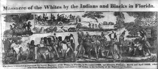
Right click
here to download print-ready file
Caption info: "Massacre of the Whites by the Indians and
Blacks in Florida," engraving published by D.F. Blanchard, 1836.
This engraving was published by Blanchard in "An Authentic Narrative
of the Seminole War: Its Cause, Rise and Progress, and a Minute
Detail of the Horrid Massacres of the Whites, by the Indians and
Negroes, in Florida, in the Months of December, January and
February" (Providence: Printed for D.F. Blanchard and others
publishers, 1836).
The image purports to depict the "horrid Massacre of the Whites in
Florida" from December 1835 to April 1836, when "near Four Hundred
(including women and children) fell victim to the barbarity of the
Negroes and Indians." Noteworthy for its frank depiction of black
violence, the engraving is one of the only surviving images from
early American history that depicts blacks and Indians fighting as
allies. The image also appears to capture, in all its melodrama and
horror, the initial Southern reaction to the Black Seminole uprising
of 1835-36. |
|
|
|
|
|
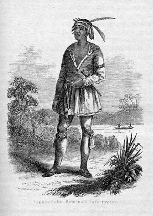
Right
click here to download print-ready file
Caption info: Engraving of John Horse, aka Gopher John,
attributed to N. Orr of "N. Orr & Richardson, S.C., N.Y.," published
in Joshua Reed Giddings' 1858 history, The Exiles of Florida. Gopher
John was John Horse's sobriquet among military officers, based on an
incident from his childhood when he resold the same two gopher tortoises
to an officer at Fort Brooke for a week. N. Orr was credited with
another engraving of John Horse from 1848 that accompanied John T.
Sprague's history of the war. See a
comparison
of the images here. |
|
|
|
|
|
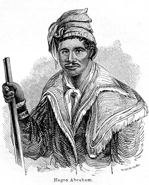
Right
click here to download print-ready file
Caption info: Abraham, from N. Orr's engraving published in
1848 in The Origin, Progress, and Conclusion of the Florida War by
John T. Sprague. |
|
|
|
|
|
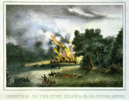
Right click here to download print-ready file
Caption info: "Burning of the town Pilak-li-ka-ha by Gen.
Eustis," one of six engravings from "Lithographs of Events in the
Seminole War in Florida in 1835," hand-colored lithographs
attributed to Gray & James, created in 1836-37. On March 31, 1836,
General Eustis' men came upon the Black Seminole town of Pilkalikaha.
Finding it deserted, they burned the village, which was also known
as "Abraham's town" for its identification with the Black Seminole
leader. The destruction of Pilklakaha was one of the few successes
for the Americans during the first year of the war -- by some
accounts, it was the only success. Even so, the illustration does
not overly embellish the event as an American triumph. |
|
|
|
|
|
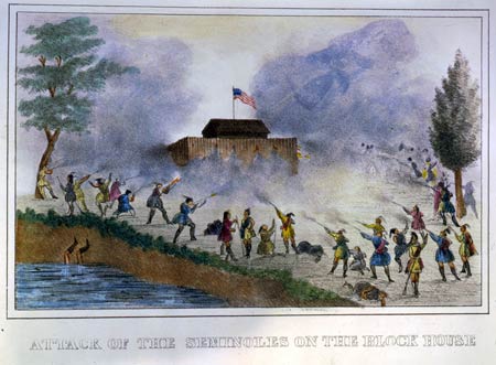
Right
click here to download print-ready file
Caption info: "Attack of the Seminoles on the block house,"
one of six engravings from "Lithographs of Events in the Seminole
War in Florida in 1835," hand-colored lithographs attributed to Gray
& James, created in 1836-37. On April 4, 1836, fifty Americans were
garrisoned at a block house twelve miles south of the Withlacoochee.
The Seminoles attacked the block house on April 12, and in an action
uncharacteristic in American Indian warfare, they kept the structure
surrounded for forty-five days. Depicting four dead and several
wounded among the Seminole allies, the piece probably exaggerated
their casualties, but nonetheless depicted an Indian success in
progress. More notable is the complete absence of blacks from the
Seminole ranks. Contrary to the image, it is highly unlikely that
blacks were absent from the siege, which took place only months
after the plantation uprisings at the outset of the war. Military
reports placed Black Seminoles in the vanguard of many battles and a
former field slave in command of at least one. A truthful depiction
of the enemy ranks may have been too controversial for Gray & James
and their Charleston audience. |
|
|
|
|
|

Right click
here to download print-ready file
Caption info: Arrival of the So. Ca. Dragoons at the
Withlacoochee, one of six engravings from "Lithographs of Events in
the Seminole War in Florida in 1835," hand-colored lithographs
attributed to Gray & James, created in 1836-37. The South Carolina
dragoons under Eustis would have explored the Withlacoochee in late
March or early April. The collapsed bridge at the right was quite
possibly the temporary structure that General Duncan Clinch erected
during the first battle on the Withlacoochee (December 31, 1835)
when he was forced to retreat. Once again, the illustration depicts
calm, even genteel soldiers on the verge of action -- before the
storm. The whole scene, from the casually conversing men in the left
background to the overwhelming subtropical foliage, illustrates
General Jesup's contention that in Florida, "The difficulty is not
to fight the enemy, but to find him." |
|
|
|
|
|
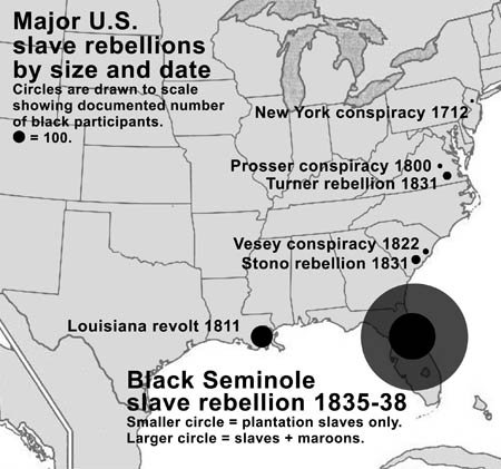
Right
click here to download print-ready file
Caption info: This map, created for
www.johnhorse.com and based on the original research on the
site, shows the relative size of the largest slave rebellions in
U.S. history based on the best estimates from credible academic and
primary sources. For the sources used to create this map, see the
table on U.S. slave rebellions in the essay, "The largest slave
rebellion in U.S. history." All use must be credited to
www.johnhorse.com. Note: The original Photoshop file is
available for users who want to customize the appearance of the map.
A color version is on
the site. |
|
|
|
|
|
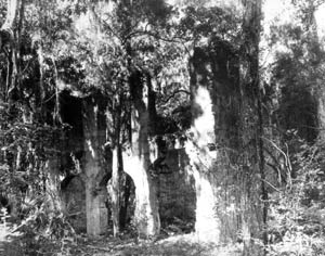
Right
click here to download print-ready file
Caption info: Bulow plantation ruins, on the site today of
the Bulow Plantation Ruins Historic State Park. Historian Mark F. Boyd wrote about the destruction
of John J. Bulow's plantation and 20 other plantations during the
uprisings at the onset of the Second Seminole War in 1835-36.
According to Boyd, the Seminole allies sacked "Bulowville," as
the plantation was known, shortly after the military withdrew
from the location on January 23, 1836, at a time when "the whole
of east Florida" was described as being "in the hands of the
enemy," including Seminole Indians, Black Seminole maroons, and
more than 300 plantation slave rebels. (For Boyd's original research, see this
free, online edition of the 1951-52 issue of Florida Historical
Quarterly and go to "A Sugar Empire Dissolves.") |
|
|
|
|
|
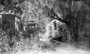
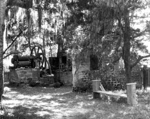
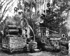
The following 6 images are all from the Florida Photographic
Collection where they are listed with the title, "Ruins of Dunlawton
Sugar Plantation mill : Port Orange, Florida" and the following
additional information: Also known as Sugar Mill Gardens, 3
miles south of Daytona Beach, Florida. Ruins and massive old English
sugar-making equipment are enshrined in a lovely garden setting with
thousands of flowering plants, cathedral oaks and sweeping lawns.
Additional caption info for all 6 images of the Dunlawton
Plantation ruins: Historian Mark F. Boyd wrote about the destruction
of Dunlawton and 20 other plantations during the uprisings at the
onset of the Second Seminole War in 1835-36. According to Boyd, the
Seminole allies and their slave recruits plundered and burned
Dunlawton in January of 1836. The plantation was later rebuilt in
1850. (For Boyd's original research, see this
free, online edition of the 1951-52 issue of Florida Historical
Quarterly and go to "A Sugar Empire Dissolves.")
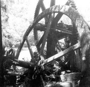
Right
click here to download print-ready file
Caption info: Sugar mill ruins at Dunlawton plantation. See
above for more detail.
Right
click here to download print-ready file
Caption info: Ruins at Dunlawton plantation. See above for
more detail.
Right
click here to download print-ready file
Caption info: Ruins at Dunlawton plantation. See above for
more detail.
Right
click here to download print-ready file
Caption info: Ruins at Dunlawton plantation. See above for
more detail.
Right
click here to download print-ready file
Caption info: Ruins at Dunlawton plantation. See above for
more detail.

Right
click here to download print-ready file
Caption info: Ruins at Dunlawton plantation. See above for
more detail. |
|
|
|
|
|
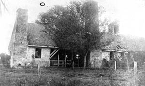
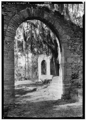
The following 7 images are all from the Florida Photographic
Collection which lists them under various titles (noted below with
each image) as depicting the ruins of the sugar mill or the "old
Spanish mission" at New Smyrna.
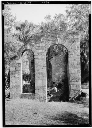
Additional caption info for all 7
images of the New Smyrna/old Spanish mission ruins: Florida Historian Mark F. Boyd wrote about the destruction
of the New Smyrna plantation owned by "Messrs. Cruger and Depeyster"
during the uprisings at the onset of the Second Seminole War in
1835-36. At the height of the January 1836 uprising, the Seminole
allies burned all of the buildings on the Cruger and Depeyster
estate, including the sugar mill. A later owner was convinced that
the ruins of the steam-operated mills dated to the Spanish colonial
era, identifying them as Jororo de Atocuimi. This fanciful
identification persisted in tourist postcards. Apparently it was
more exotic to describe the site as an old Spanish ruin than the
ruin of a slave-Indian-maroon uprising. (For Boyd's original research, see this
free, online edition of the 1951-52 issue of Florida Historical
Quarterly and go to "A Sugar Empire Dissolves.")
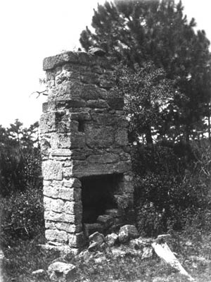
Right click
here to download print-ready file
Caption info: Described by the Florida Photographic
Collection, inaccurately, as "Fireplace in ruins of a Mission of
Atocuimi : New Smyrna, Florida." See note above.
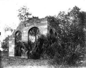
Right click
here to download print-ready file
Caption info: Described by the Florida Photographic
Collection as "Ruins of a sugar mill : New Smyrna, Florida." See
note above.
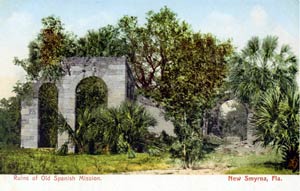
Right click
here to download print-ready file
Caption info: Described by the Florida Photographic
Collection as "Ruins of old Spanish mission : New Smyrna, Florida,"
based on fanciful tourist postcard. See note above.
Right click
here to download print-ready file
Caption info: Described by the Florida Photographic
Collection as "New Smyrna Sugar Mill Ruins State Park : Volusia
County, Florida," and identified inaacurately with the fanciful
"Mission of Atocuimi." See note above.
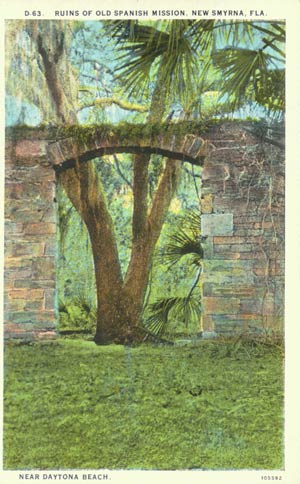
Right click
here to download print-ready file
Caption info: Described by the Florida Photographic
Collection "View of ruins of old Spanish mission : New Smyrna,
Florida," based on a fanciful postcard. See note above.
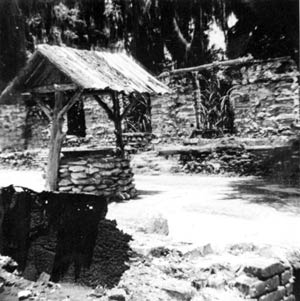
Right click
here to download print-ready file
Caption info: Described by the Florida Photographic
Collection as "Well at an old sugar mill : New Smyrna Beach,
Florida," with this accurate note: "Part of the sugar mill ruins at
New Smyrna Beach. They were built in 1830 by Henry Cruger and
William Depeyster. Five years later, they were destroyed by Seminole
raids during the Second Seminole War."
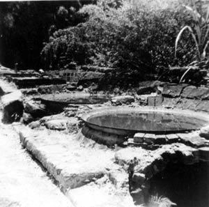
Right click
here to download print-ready file
Caption info: Described by the Florida Photographic
Collection as "Old syrup kettles : New Smyrna Beach, Florida," with
this accurate note: "Part of the sugar mill ruins at New Smyrna
Beach. They were built in 1830 by Henry Cruger and William Depeyster.
Five years later, they were destroyed by Seminole raids during the
Second Seminole War." |
|
|
|
|
|
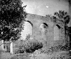
All 3 images below are identified as being of the "New Smyrna
Sugar Mill (ruins), New Smyrna vicinity, Volusia County, FL," from
the Hisoric American Buildings Survey images archived at the Library
of Congress. The photographer was R.H. Lesesne, 1934.
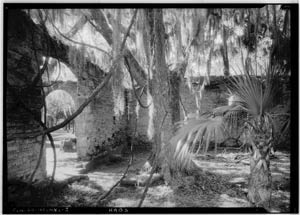
Right click
here to download print-ready file
Caption info: See
above note on the 7 preceding New Smyrna images.
Right click
here to download print-ready file
Caption info: See
above note on the 7 preceding New Smyrna images.
Right click
here to download print-ready file
Caption info: See
above note on the 7 preceding New Smyrna images. |
|
|
|
|
|
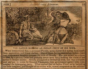
Right click
here to download print-ready file
Caption info: "The Nation Robbing An Indian Chief of His
Wife," engraving by an anonymous artist created for the The American
Anti-Slavery Almanac of 1839. Depicting the legendary kidnapping of
Osceola's half-black wife, this engraving from The Anti-Slavery
Almanac of 1839 stands on the other side of the political spectrum
from many images of the time because it expresses blatant sympathy
for Native and African Americans. The engraving mocks American
principles of liberty at the time, noting that while "monarchical"
Spain sheltered fugitive blacks, "republican" America placed their
children in chains. Though the engraving contributed to—and may have
initiated—the legend that Osceola had a black wife, for which there
is no solid historical evidence, nonetheless, the engraving's
details captured the essence of events leading up to the Second
Seminole War. The engraving and caption are also among the earliest
surviving representations of the Black Seminoles. |
|
|
|
|
|
|